
Mering topographic map
Click on the map to display elevation.
About this map
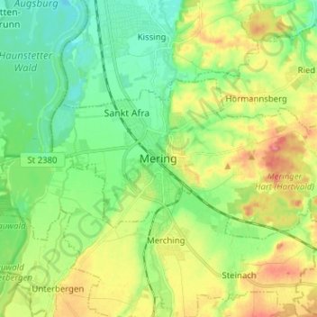
Name: Mering topographic map, elevation, terrain.
Location: Mering, Landkreis Aichach-Friedberg, Bavaria, 86415, Germany (48.24522 10.94038 48.28796 11.06679)
Average elevation: 1,713 ft
Minimum elevation: 1,614 ft
Maximum elevation: 1,867 ft
Other topographic maps
Click on a map to view its topography, its elevation and its terrain.
Sankt Stephan
Germany > Bavaria > Landkreis Aichach-Friedberg > Sankt Stephan
Average elevation: 1,457 ft