
Make a donation
Gear up for your next adventure:
As an Amazon Associate, this site earns from qualifying purchases at no extra cost to you.
Huambo topographic map
Click on the map to display elevation.
Make a donation
Gear up for your next adventure:
As an Amazon Associate, this site earns from qualifying purchases at no extra cost to you.
About this map
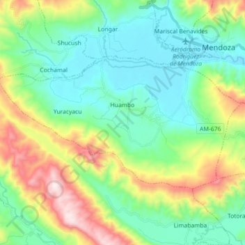
Name: Huambo topographic map, elevation, terrain.
Location: Huambo, Rodríguez de Mendoza, Amazonas, Peru (-6.47724 -77.60993 -6.40083 -77.46880)
Average elevation: 6,024 ft
Minimum elevation: 5,072 ft
Maximum elevation: 8,360 ft
Make a donation
Gear up for your next adventure:
As an Amazon Associate, this site earns from qualifying purchases at no extra cost to you.
Other topographic maps
Click on a map to view its topography, its elevation and its terrain.
Catarata del Gocta
Peru > Amazonas > San Carlos
Der peruanische Wasserfall Gocta ist mit 771 Metern Fallhöhe einer der höchsten der Erde. Sein Wasservolumen schwankt sehr stark, je nach dem augenblicklichen Niederschlag in seinem kleinen, felsigen Einzugsgebiet, das in einer Höhe zwischen 2500 und 3000 m liegt. Er befindet sich in der Provinz Bongará…
Average elevation: 8,271 ft
Make a donation
Gear up for your next adventure:
As an Amazon Associate, this site earns from qualifying purchases at no extra cost to you.