
Make a donation
Gear up for your next adventure:
As an Amazon Associate, this site earns from qualifying purchases at no extra cost to you.
Boutaleb topographic map
Click on the map to display elevation.
Make a donation
Gear up for your next adventure:
As an Amazon Associate, this site earns from qualifying purchases at no extra cost to you.
Boutaleb
Située à une altitude de 860 mètres la ville de Boutaleb est tout proche des Aurès, elle possède un climat semi-aride sec et les hivers peuvent être très froids.
Make a donation
Gear up for your next adventure:
As an Amazon Associate, this site earns from qualifying purchases at no extra cost to you.
About this map
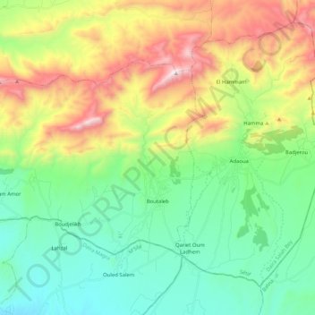
Name: Boutaleb topographic map, elevation, terrain.
Location: Boutaleb, Daïra Salah Bey, Sétif, Algérie (35.63089 5.14761 35.73471 5.35201)
Average elevation: 3,428 ft
Minimum elevation: 2,110 ft
Maximum elevation: 6,099 ft
Make a donation
Gear up for your next adventure:
As an Amazon Associate, this site earns from qualifying purchases at no extra cost to you.
Other topographic maps
Click on a map to view its topography, its elevation and its terrain.