
Make a donation
Gear up for your next adventure:
As an Amazon Associate, this site earns from qualifying purchases at no extra cost to you.
Pontebba topographic map
Click on the map to display elevation.
Make a donation
Gear up for your next adventure:
As an Amazon Associate, this site earns from qualifying purchases at no extra cost to you.
About this map
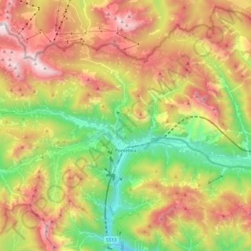
Name: Pontebba topographic map, elevation, terrain.
Location: Pontebba, Udine, Friuli – Venezia Giulia, 33016, Italy (46.46805 13.20536 46.57007 13.38964)
Average elevation: 4,229 ft
Minimum elevation: 1,430 ft
Maximum elevation: 7,457 ft
Make a donation
Gear up for your next adventure:
As an Amazon Associate, this site earns from qualifying purchases at no extra cost to you.
Other topographic maps
Click on a map to view its topography, its elevation and its terrain.
Tribil Superiore / Gorenji Tarbij
Italy > Friuli – Venezia Giulia > Udine > Stregna
Average elevation: 1,640 ft
Make a donation
Gear up for your next adventure:
As an Amazon Associate, this site earns from qualifying purchases at no extra cost to you.
Make a donation
Gear up for your next adventure:
As an Amazon Associate, this site earns from qualifying purchases at no extra cost to you.
Timau / Tischlbong
Italy > Friuli – Venezia Giulia > Udine > Paluzza / Paluce / Palutsch
Average elevation: 4,288 ft
Sauris di Sopra / Plozn / Sauris Disore
Italy > Friuli – Venezia Giulia > Udine
Average elevation: 4,820 ft
Make a donation
Gear up for your next adventure:
As an Amazon Associate, this site earns from qualifying purchases at no extra cost to you.