
Make a donation
Gear up for your next adventure:
As an Amazon Associate, this site earns from qualifying purchases at no extra cost to you.
Luppa topographic map
Click on the map to display elevation.
Make a donation
Gear up for your next adventure:
As an Amazon Associate, this site earns from qualifying purchases at no extra cost to you.
Luppa
2002 fand bereits das dritte Dreschmaschinenfest in Luppa statt. Höhepunkt des Festes ist ein Umzug mit historischer Landmaschinentechnik.
Make a donation
Gear up for your next adventure:
As an Amazon Associate, this site earns from qualifying purchases at no extra cost to you.
About this map
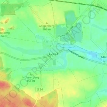
Name: Luppa topographic map, elevation, terrain.
Location: Luppa, Wermsdorf, Nordsachsen, Sachsen, 04779, Deutschland (51.31311 12.94002 51.35311 12.98002)
Average elevation: 509 ft
Minimum elevation: 446 ft
Maximum elevation: 614 ft
Make a donation
Gear up for your next adventure:
As an Amazon Associate, this site earns from qualifying purchases at no extra cost to you.
Other topographic maps
Click on a map to view its topography, its elevation and its terrain.