
Make a donation
Gear up for your next adventure:
As an Amazon Associate, this site earns from qualifying purchases at no extra cost to you.
Fleurimont topographic map
Click on the map to display elevation.
Make a donation
Gear up for your next adventure:
As an Amazon Associate, this site earns from qualifying purchases at no extra cost to you.
Fleurimont
Installé sur la rive gauche de la ravine Bernica, Fleurimont est situé entre 200 et 400 mètres d'altitude au croisement de deux routes départementales : la D6 et la D8, cette dernière commençant au cœur du bourg pour grimper ensuite jusqu'au Bernica. L'autre la relie au centre-ville de Saint-Paul, plus au nord, à Saint-Gilles-les-Hauts, plus au sud.
Make a donation
Gear up for your next adventure:
As an Amazon Associate, this site earns from qualifying purchases at no extra cost to you.
About this map
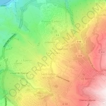
Name: Fleurimont topographic map, elevation, terrain.
Location: Fleurimont, Saint-Paul, La Réunion, 97435, France (-21.05801 55.24857 -21.01801 55.28857)
Average elevation: 1,007 ft
Minimum elevation: 0 ft
Maximum elevation: 1,952 ft
Make a donation
Gear up for your next adventure:
As an Amazon Associate, this site earns from qualifying purchases at no extra cost to you.
Other topographic maps
Click on a map to view its topography, its elevation and its terrain.
Ravine Saint-Gilles
France > La Réunion > Saint-Paul > Saint-Gilles-les-Hauts > Village de l'Éperon
Average elevation: 1,017 ft
Make a donation
Gear up for your next adventure:
As an Amazon Associate, this site earns from qualifying purchases at no extra cost to you.