
Make a donation
Gear up for your next adventure:
As an Amazon Associate, this site earns from qualifying purchases at no extra cost to you.
Glenns topographic map
Click on the map to display elevation.
Make a donation
Gear up for your next adventure:
As an Amazon Associate, this site earns from qualifying purchases at no extra cost to you.
About this map
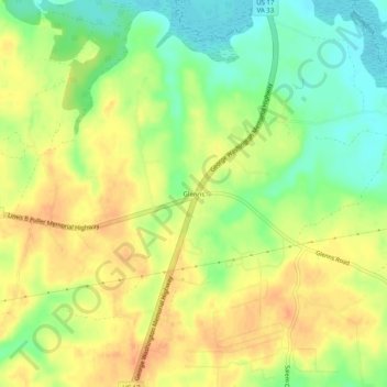
Name: Glenns topographic map, elevation, terrain.
Location: Glenns, Gloucester County, Virginia, 23149, United States (37.54585 -76.63296 37.58585 -76.59296)
Average elevation: 75 ft
Minimum elevation: 0 ft
Maximum elevation: 131 ft
Gloucester County trails, hiking, mountain biking, running and outdoor activities
Make a donation
Gear up for your next adventure:
As an Amazon Associate, this site earns from qualifying purchases at no extra cost to you.
Other topographic maps
Click on a map to view its topography, its elevation and its terrain.
Gloucester Point
United States > Virginia > Gloucester County > Gloucester Point
Average elevation: 16 ft