Geolocate

Golden Point topographic map

Click on the map to display elevation.

About this map
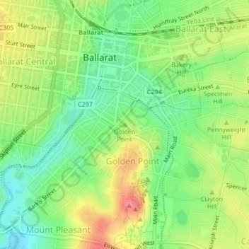
Name: Golden Point topographic map, elevation, terrain.

Location: Golden Point, Ballarat, City of Ballarat, Victoria, 3350, Australia (-37.56967 143.86390 -37.56957 143.86400)

Average elevation: 1,427 ft

Minimum elevation: 1,316 ft

Maximum elevation: 1,565 ft

Other topographic maps

Click on a map to view its topography, its elevation and its terrain.
Lake Wendouree

Australia > Victoria > Ballarat

Average elevation: 1,483 ft

Chisholm Street Reserve

Australia > Victoria > Ballarat

Average elevation: 1,519 ft

Mount Rowan

Australia > Victoria > Ballarat

Average elevation: 1,490 ft

Kirks Reservoir

Australia > Victoria > Ballarat

Average elevation: 1,759 ft

Alfredton

Australia > Victoria > Ballarat

Average elevation: 1,476 ft

Sebastopol

Australia > Victoria > Ballarat

Average elevation: 1,358 ft

Brown Hill

Australia > Victoria > Ballarat

Average elevation: 1,660 ft

Magpie

Australia > Victoria > Ballarat

Average elevation: 1,339 ft

Gear up for your next adventure:

🏔️Mountain Trail Maps - High‑detail maps for popular peaks
🧥Men's Rain Shells - Premium waterproof and breathable jackets for mountain weather
🔌USB Car Charger - Car charger for on‑the‑go power needs
🔊Portable Camp Speaker - Music and alerts at camp
🪶Camping Sleeping Pad - Comfortable sleeping pad for backpacking

As an Amazon Associate, this site earns from qualifying purchases at no extra cost to you.