
Thank you for supporting this site ❤️
Make a donation
Make a donation
Gear up for your next adventure:
As an Amazon Associate, this site earns from qualifying purchases at no extra cost to you.
Pansaleo topographic map
Click on the map to display elevation.
Thank you for supporting this site ❤️
Make a donation
Make a donation
Gear up for your next adventure:
As an Amazon Associate, this site earns from qualifying purchases at no extra cost to you.
About this map
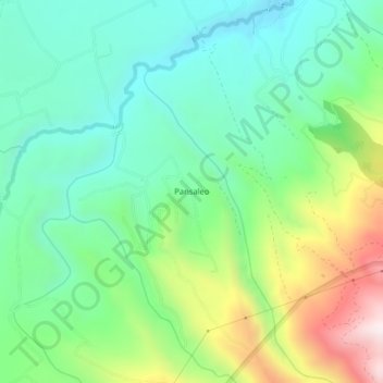
Name: Pansaleo topographic map, elevation, terrain.
Location: Pansaleo, Machachi, Pichincha, 171111, Ecuador (-0.57268 -78.58042 -0.53268 -78.54042)
Average elevation: 10,351 ft
Minimum elevation: 9,570 ft
Maximum elevation: 12,070 ft
Thank you for supporting this site ❤️
Make a donation
Make a donation
Gear up for your next adventure:
As an Amazon Associate, this site earns from qualifying purchases at no extra cost to you.