Geolocate

Alvaton topographic map

Click on the map to display elevation.

About this map

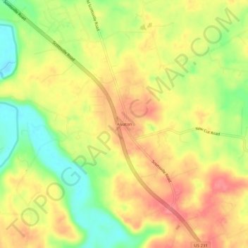
Name: Alvaton topographic map, elevation, terrain.

Location: Alvaton, Warren County, Kentucky, 42122, United States (36.85338 -86.37305 36.89338 -86.33305)

Average elevation: 597 ft

Minimum elevation: 456 ft

Maximum elevation: 702 ft

Warren County trails, hiking, mountain biking, running and outdoor activities

Other topographic maps

Click on a map to view its topography, its elevation and its terrain.

Bowling Green

United States > Kentucky > Warren County

Average elevation: 554 ft

Smiths Grove

United States > Kentucky > Warren County

Average elevation: 633 ft

Oakland

United States > Kentucky > Warren County

Average elevation: 591 ft

Bowling Green

United States > Kentucky > Warren County

Average elevation: 554 ft

Bowling Green

United States > Kentucky > Warren County

Average elevation: 554 ft

Gear up for your next adventure:

🌧️Backpack Rain Cover - Keep gear dry in wet weather
🌎3D Topographic Globes - Raised relief globes for a tactile understanding of geography
📡Handheld GPS Device - Reliable handheld GPS for outdoor navigation
📶Vehicle Signal Boosters - Improve reception in rural areas while driving to trailheads
🔦LED Headlamp - Bright and durable LED headlamp for night navigation

As an Amazon Associate, this site earns from qualifying purchases at no extra cost to you.