
Make a donation
Gear up for your next adventure:
As an Amazon Associate, this site earns from qualifying purchases at no extra cost to you.
Elzach topographic map
Click on the map to display elevation.
Make a donation
Gear up for your next adventure:
As an Amazon Associate, this site earns from qualifying purchases at no extra cost to you.
Elzach
The town of Elzach is located at the eastern border of the district of Emmendingen and borders on the district of the Ortenaukreis and the Schwarzwald-Baar-Kreis. Topographically is the area characterised by the river valley of the Elz and the local hill called Rohrhardsberg. Also Elzach belongs to the Breisgau area and is located at the edge of the Southern Black Forest Nature Park.
Make a donation
Gear up for your next adventure:
As an Amazon Associate, this site earns from qualifying purchases at no extra cost to you.
About this map
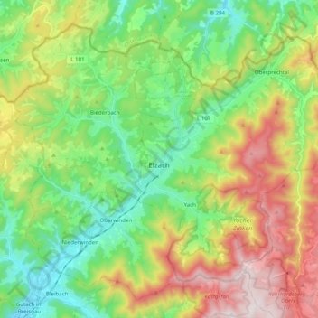
Name: Elzach topographic map, elevation, terrain.
Average elevation: 1,988 ft
Minimum elevation: 925 ft
Maximum elevation: 3,842 ft
Make a donation
Gear up for your next adventure:
As an Amazon Associate, this site earns from qualifying purchases at no extra cost to you.
Other topographic maps
Click on a map to view its topography, its elevation and its terrain.
Broggingen
Germany > Baden-Württemberg > Landkreis Emmendingen > Herbolzheim
Average elevation: 820 ft