Geolocate

Dover topographic map

Click on the map to display elevation.

About this map

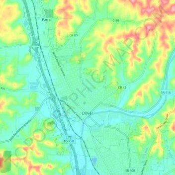
Name: Dover topographic map, elevation, terrain.

Location: Dover, Tuscarawas County, Ohio, 44622, United States (40.49511 -81.50647 40.56950 -81.44876)

Average elevation: 961 ft

Minimum elevation: 843 ft

Maximum elevation: 1,234 ft

Tuscarawas County trails, hiking, mountain biking, running and outdoor activities

Other topographic maps

Click on a map to view its topography, its elevation and its terrain.

Yorktown

United States > Ohio > Tuscarawas County

Average elevation: 1,004 ft

Dundee

United States > Ohio > Tuscarawas County

Average elevation: 1,076 ft

Barrs Mills

United States > Ohio > Tuscarawas County

Average elevation: 1,060 ft

Sugar Creek

United States > Ohio > Tuscarawas County > Strasburg

Average elevation: 1,024 ft

Gear up for your next adventure:

🛰️Handheld GPS Units - Professional satellite navigators for precise backcountry mapping
🛶Inflatable Kayak - Portable kayak for rivers, lakes, and expeditions
🥄Camping Utensil Set - Lightweight utensils for outdoor meals
🪵Folding Camp Saw - Compact saw for wood and campsite work
🧥Men's Rain Shells - Premium waterproof and breathable jackets for mountain weather

As an Amazon Associate, this site earns from qualifying purchases at no extra cost to you.