
Make a donation
Gear up for your next adventure:
As an Amazon Associate, this site earns from qualifying purchases at no extra cost to you.
Fatu Huku topographic map
Click on the map to display elevation.
Make a donation
Gear up for your next adventure:
As an Amazon Associate, this site earns from qualifying purchases at no extra cost to you.
Fatu Huku
The island is essentially a huge rock, looming steep-sided out of the ocean and rising to a flattened plateau with a maximum elevation of 361 metres (1,184 ft). Fatu Huku is the youngest of the volcanic Marquesas Islands, estimated to be only 1.3 million years old which accounts, in part, for its ruggedness as erosion has not yet carved out valleys and beaches. Coral is rare in the Marquesas, but a fossilized ancient coral reef is found at the higher elevations of Fatu Huku. The island is also surrounded by a roughly triangular-shaped barrier reef that is completely submerged, but can faintly be seen on satellite images.
Make a donation
Gear up for your next adventure:
As an Amazon Associate, this site earns from qualifying purchases at no extra cost to you.
About this map
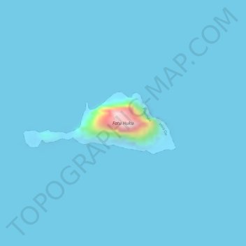
Name: Fatu Huku topographic map, elevation, terrain.
Average elevation: 26 ft
Minimum elevation: -39 ft
Maximum elevation: 1,122 ft
Make a donation
Gear up for your next adventure:
As an Amazon Associate, this site earns from qualifying purchases at no extra cost to you.
Other topographic maps
Click on a map to view its topography, its elevation and its terrain.
Moho Tani
France > French Polynesia > Marquesas Islands > Hiva Oa
It is a high island, with its highest elevation (520 meters) in the south, and its overall shape resembles the back of a whale.
Average elevation: 135 ft