Princeton topographic map
Interactive map
Click on the map to display elevation.
About this map
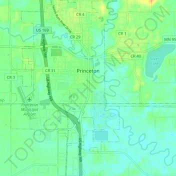
Name: Princeton topographic map, elevation, terrain.
Location: Princeton, Mille Lacs County, Minnesota, United States (45.53750 -93.61429 45.59151 -93.56660)
Average elevation: 974 ft
Minimum elevation: 945 ft
Maximum elevation: 1,040 ft
Other topographic maps
Click on a map to view its topography, its elevation and its terrain.
Rum River
United States > Minnesota > Mille Lacs County
Rum River, Princeton Township, Mille Lacs County, Minnesota, 55371, United States
Average elevation: 994 ft
Onamia
United States > Minnesota > Mille Lacs County
Onamia, Mille Lacs County, Minnesota, United States
Average elevation: 1,257 ft
Isle
United States > Minnesota > Mille Lacs County > Isle
Isle, Mille Lacs County, Minnesota, United States
Average elevation: 1,273 ft
Mille Lacs Lake
United States > Minnesota > Mille Lacs County
Mille Lacs Lake, Mille Lacs County, Minnesota, 56432, United States
Average elevation: 1,257 ft
Milaca
United States > Minnesota > Mille Lacs County
Milaca, Mille Lacs County, Minnesota, United States
Average elevation: 1,079 ft