
Make a donation
Gear up for your next adventure:
As an Amazon Associate, this site earns from qualifying purchases at no extra cost to you.
Arapaho topographic map
Click on the map to display elevation.
Make a donation
Gear up for your next adventure:
As an Amazon Associate, this site earns from qualifying purchases at no extra cost to you.
About this map
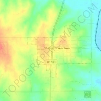
Name: Arapaho topographic map, elevation, terrain.
Location: Arapaho, Custer County, Oklahoma, 73620, United States (35.56986 -98.97219 35.58419 -98.94898)
Average elevation: 1,621 ft
Minimum elevation: 1,539 ft
Maximum elevation: 1,709 ft
Custer County trails, hiking, mountain biking, running and outdoor activities
Make a donation
Gear up for your next adventure:
As an Amazon Associate, this site earns from qualifying purchases at no extra cost to you.
Other topographic maps
Click on a map to view its topography, its elevation and its terrain.
Weatherford
United States > Oklahoma > Custer County > Weatherford > Weatherford
Weatherford is located at 35°32′18″N 98°41′14″W / 35.53833°N 98.68722°W / 35.53833; -98.68722 (35.5384097, -98.6872467). The elevation is 1,634 feet (498 m). According to the United States Census Bureau, the city has a total area of 7.05 square miles (18.3 km2), all land.
Average elevation: 1,696 ft