
Make a donation
Gear up for your next adventure:
As an Amazon Associate, this site earns from qualifying purchases at no extra cost to you.
La Unión topographic map
Click on the map to display elevation.
Make a donation
Gear up for your next adventure:
As an Amazon Associate, this site earns from qualifying purchases at no extra cost to you.
About this map
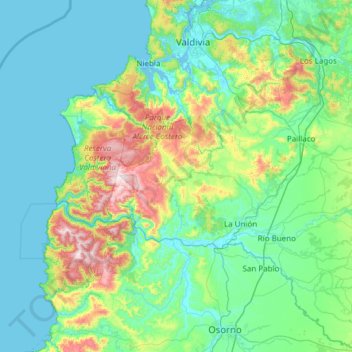
Name: La Unión topographic map, elevation, terrain.
Average elevation: 525 ft
Minimum elevation: -7 ft
Maximum elevation: 3,389 ft
Make a donation
Gear up for your next adventure:
As an Amazon Associate, this site earns from qualifying purchases at no extra cost to you.
Other topographic maps
Click on a map to view its topography, its elevation and its terrain.
Mantilhue Centro Sur
Chile > Región de Los Ríos > Provincia de Ranco > Río Bueno
Average elevation: 676 ft
Make a donation
Gear up for your next adventure:
As an Amazon Associate, this site earns from qualifying purchases at no extra cost to you.
Cerro Huequecura
Chile > Región de Los Ríos > Provincia de Ranco > Futrono
Average elevation: 1,352 ft
Make a donation
Gear up for your next adventure:
As an Amazon Associate, this site earns from qualifying purchases at no extra cost to you.
Yaquito
Chile > Región de Los Ríos > Provincia de Ranco > Comuna de La Unión
Average elevation: 240 ft
Mirador Llaquito
Chile > Región de Los Ríos > Provincia de Ranco > Comuna de La Unión > Yaquito
Average elevation: 190 ft
Make a donation
Gear up for your next adventure:
As an Amazon Associate, this site earns from qualifying purchases at no extra cost to you.
Make a donation
Gear up for your next adventure:
As an Amazon Associate, this site earns from qualifying purchases at no extra cost to you.
Make a donation
Gear up for your next adventure:
As an Amazon Associate, this site earns from qualifying purchases at no extra cost to you.
Volcán Puyehue
Chile > Región de Los Ríos > Provincia de Ranco > Río Bueno
Las partes bajas de las montañas están sujetas a características alpinas de vegetación, clásico del bosque valdiviano, donde especies como la Chusquea culeou y Nothofagus dombeyi son comunes. La línea de árboles, descansa en una altitud de 1500 m, mayoritariamente Nothofagus pumilio. Sobre esta línea…
Average elevation: 6,496 ft