
Make a donation
Gear up for your next adventure:
As an Amazon Associate, this site earns from qualifying purchases at no extra cost to you.
Oberhalberg topographic map
Click on the map to display elevation.
Make a donation
Gear up for your next adventure:
As an Amazon Associate, this site earns from qualifying purchases at no extra cost to you.
Oberhalberg
Der Weiler liegt in einer Höhe von 170 bis 200 Metern über N.N. auf den Hängen des Bergischen Landes und des Nutscheid in der Gemarkung Lauthausen. Ein Ortsteil ist der westlich gelegene ehemalige Wohnplatz Oppelrath. Nachbarort ist Niederhalberg im Süden.
Make a donation
Gear up for your next adventure:
As an Amazon Associate, this site earns from qualifying purchases at no extra cost to you.
About this map
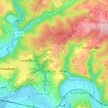
Name: Oberhalberg topographic map, elevation, terrain.
Average elevation: 495 ft
Minimum elevation: 226 ft
Maximum elevation: 869 ft
Make a donation
Gear up for your next adventure:
As an Amazon Associate, this site earns from qualifying purchases at no extra cost to you.