
Make a donation
Gear up for your next adventure:
As an Amazon Associate, this site earns from qualifying purchases at no extra cost to you.
Hughes topographic map
Click on the map to display elevation.
Make a donation
Gear up for your next adventure:
As an Amazon Associate, this site earns from qualifying purchases at no extra cost to you.
About this map
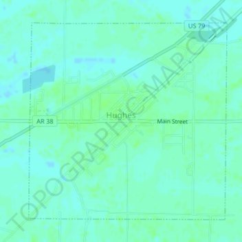
Name: Hughes topographic map, elevation, terrain.
Location: Hughes, St. Francis County, Arkansas, United States (34.93733 -90.48422 34.95933 -90.45721)
Average elevation: 203 ft
Minimum elevation: 190 ft
Maximum elevation: 213 ft
St. Francis County trails, hiking, mountain biking, running and outdoor activities
Make a donation
Gear up for your next adventure:
As an Amazon Associate, this site earns from qualifying purchases at no extra cost to you.
Other topographic maps
Click on a map to view its topography, its elevation and its terrain.
Palestine
United States > Arkansas > St. Francis County > Palestine > Palestine
Average elevation: 207 ft
Forest Lake Number 3 Dam
United States > Arkansas > St. Francis County > Forrest City
Average elevation: 305 ft
Make a donation
Gear up for your next adventure:
As an Amazon Associate, this site earns from qualifying purchases at no extra cost to you.