
Make a donation
Gear up for your next adventure:
As an Amazon Associate, this site earns from qualifying purchases at no extra cost to you.
Mambach topographic map
Click on the map to display elevation.
Make a donation
Gear up for your next adventure:
As an Amazon Associate, this site earns from qualifying purchases at no extra cost to you.
About this map
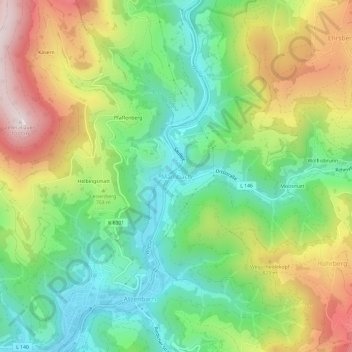
Name: Mambach topographic map, elevation, terrain.
Average elevation: 2,241 ft
Minimum elevation: 1,421 ft
Maximum elevation: 3,504 ft
Make a donation
Gear up for your next adventure:
As an Amazon Associate, this site earns from qualifying purchases at no extra cost to you.
Other topographic maps
Click on a map to view its topography, its elevation and its terrain.
Gresgen
Deutschland > Baden-Württemberg > Landkreis Lörrach > Zell im Wiesental
Klimatisch macht sich die Höhendifferenz von rund 300 Metern gegenüber Zell bemerkbar. So beginnt die Apfelblüte in den Bergorten wie Gresgen in der Regel erst Mitte Mai und damit rund eineinhalb Wochen später als im Tal. Auch ist die Niederschlagsmenge gegenüber der Zeller Kernstadt höher, die…
Average elevation: 2,156 ft