Geolocate

Mutia topographic map

Click on the map to display elevation.

About this map

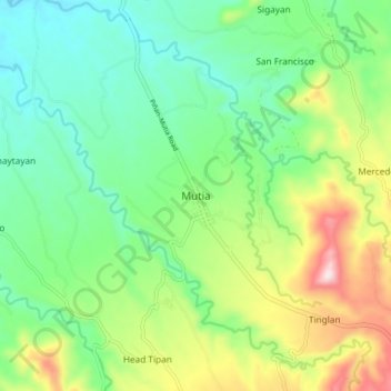
Name: Mutia topographic map, elevation, terrain.

Location: Mutia, Zamboanga del Norte, Zamboanga Peninsula, Philippines (8.38002 123.43628 8.46002 123.51628)

Average elevation: 594 ft

Minimum elevation: 98 ft

Maximum elevation: 1,624 ft

Other topographic maps

Click on a map to view its topography, its elevation and its terrain.

Sibuco

Philippines > Zamboanga del Norte

Average elevation: 581 ft

Dapitan River

Philippines > Zamboanga del Norte

Average elevation: 961 ft

Sibuco

Philippines > Zamboanga del Norte

Average elevation: 581 ft

Sibuco

Philippines > Zamboanga del Norte

Average elevation: 581 ft

Sibuco

Philippines > Zamboanga del Norte

Average elevation: 581 ft

Gear up for your next adventure:

📷Action Camera - Capture your outdoor adventures in HD
🧤Tactile Hiking Gloves - Keep hands warm while operating GPS and smartphone screens
🗃️Trail First Aid Kit - Essential kit for outdoor injuries and emergencies
🎒Trekking Poles - Sturdy poles for balance and stability on rough terrain
🏕️Tent Footprint - Protect your tent base from wear

As an Amazon Associate, this site earns from qualifying purchases at no extra cost to you.