
Make a donation
Gear up for your next adventure:
As an Amazon Associate, this site earns from qualifying purchases at no extra cost to you.
Chamba topographic map
Click on the map to display elevation.
Make a donation
Gear up for your next adventure:
As an Amazon Associate, this site earns from qualifying purchases at no extra cost to you.
About this map
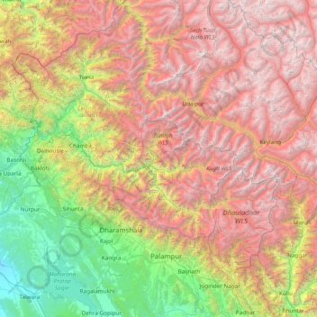
Name: Chamba topographic map, elevation, terrain.
Location: Chamba, Chamba District, Himachal Pradesh, India (31.80000 75.80000 33.20000 77.20000)
Average elevation: 9,140 ft
Minimum elevation: 843 ft
Maximum elevation: 20,584 ft
Make a donation
Gear up for your next adventure:
As an Amazon Associate, this site earns from qualifying purchases at no extra cost to you.
Other topographic maps
Click on a map to view its topography, its elevation and its terrain.
Kinnaur District
With a mountainous area, ranging in altitude from 2,320 to 6,816 metres (7,612 to 22,362 ft), Kinnaur is one of the smallest districts in India by population. It is known for the Kinnaur Kailash, a mountain sacred to Hindus, close to the Chinese border.
Average elevation: 13,885 ft