Geolocate

Anachal topographic map

Click on the map to display elevation.

About this map

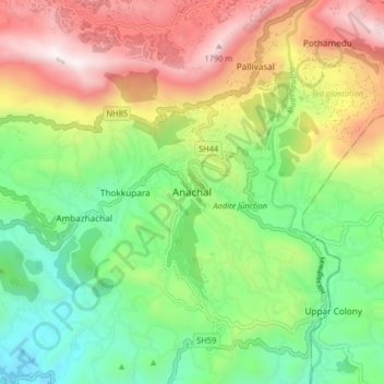
Name: Anachal topographic map, elevation, terrain.

Location: Anachal, Devikulam, Idukki, Kerala, 685565, India (9.98359 76.99800 10.06359 77.07800)

Average elevation: 3,301 ft

Minimum elevation: 1,460 ft

Maximum elevation: 6,007 ft

Other topographic maps

Click on a map to view its topography, its elevation and its terrain.

Viripara

India > Kerala > Devikulam

Average elevation: 3,750 ft

Pallivasal

India > Kerala > Devikulam > Pallivasal

Average elevation: 4,278 ft

Pothupara

India > Kerala > Devikulam > Ellakkal

Average elevation: 2,523 ft

Thalamali

India > Kerala > Devikulam > Adimali

Average elevation: 2,904 ft

Anaimudi River

India > Kerala > Devikulam

Average elevation: 4,692 ft

Mattupetty Dam

India > Kerala > Devikulam > Mattupetty

Average elevation: 5,463 ft

Anamalai

India > Kerala > Devikulam

Average elevation: 6,637 ft

Eravikulam National Park

India > Kerala > Devikulam > Lakkomukudi

Average elevation: 5,581 ft

Gear up for your next adventure:

🔋Rechargeable Batteries - Power up your outdoor devices
📱Solar Portable Charger - Solar power bank for charging devices off‑grid
🛠️Backpacking Tool Kit - Essential toolkit for outdoor repairs
🛠️Outdoor Gear Repair Kit - Essential tools to fix gear on the trail
🪶Paracord Bracelet - Survival bracelet with built‑in tools

As an Amazon Associate, this site earns from qualifying purchases at no extra cost to you.