
Make a donation
Gear up for your next adventure:
As an Amazon Associate, this site earns from qualifying purchases at no extra cost to you.
Miyoshi topographic map
Click on the map to display elevation.
Make a donation
Gear up for your next adventure:
As an Amazon Associate, this site earns from qualifying purchases at no extra cost to you.
Miyoshi
Miyoshi is located almost in the middle of the Chugoku region, with the Chugoku Mountains to the north and a flat agricultural area to the south. Together with the neighboring city of Shōbara, it forms the northern part of the prefecture called the "Bihoku region". Because the tributaries of the Enokawa River meet at the Miyoshi Basin, it prospered as a river port and has long functioned as a strategic point for culture, economy, and transportation connecting the San'in and San'yō regions. About one-third of the rain that falls in Hiroshima Prefecture is collected here, and it has abundant water. Due to the confluence of rivers, fog tends to occur in this area from late autumn to early spring. The center of urban area is the Miyoshi Basin, which is located between the Chugoku Mountains and the Kibi Plateau at an elevation of 150 to 250 meters. Miyoshi developed as a twin settlement, with "Itsukaichi", as the castle town of the Miyoshi clan towards the west, and the current city center district where Miyoshi Station is located as a market town called 'Tokaichi-machi' to the east.
Make a donation
Gear up for your next adventure:
As an Amazon Associate, this site earns from qualifying purchases at no extra cost to you.
About this map
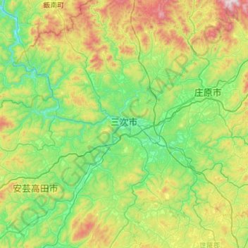
Name: Miyoshi topographic map, elevation, terrain.
Location: Miyoshi, Hiroshima Prefecture, Japan (34.60522 132.63336 35.00460 133.10966)
Average elevation: 1,266 ft
Minimum elevation: 220 ft
Maximum elevation: 3,871 ft
Make a donation
Gear up for your next adventure:
As an Amazon Associate, this site earns from qualifying purchases at no extra cost to you.
Other topographic maps
Click on a map to view its topography, its elevation and its terrain.
Make a donation
Gear up for your next adventure:
As an Amazon Associate, this site earns from qualifying purchases at no extra cost to you.
Mt. Kumotori
Mount Kumotori (雲取山, Kumotori-san) stands at the boundary of Tokyo, Saitama, and Yamanashi Prefectures on the island of Honshū, Japan. With an elevation of 2,017 metres (6,617 ft), its summit is the highest point in Tokyo. It separates the Okutama Mountains and the Okuchichibu Mountains. While it marks…
Average elevation: 5,331 ft
Make a donation
Gear up for your next adventure:
As an Amazon Associate, this site earns from qualifying purchases at no extra cost to you.