Geolocate

Hochatown topographic map

Click on the map to display elevation.

About this map

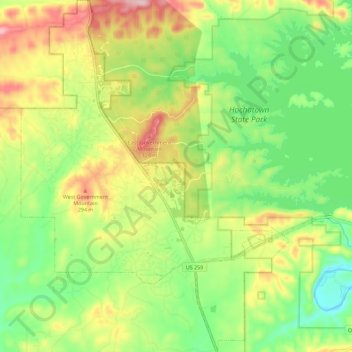
Name: Hochatown topographic map, elevation, terrain.

Location: Hochatown, McCurtain County, Oklahoma, United States (34.12113 -94.80258 34.21456 -94.71623)

Average elevation: 715 ft

Minimum elevation: 417 ft

Maximum elevation: 1,135 ft

McCurtain County trails, hiking, mountain biking, running and outdoor activities

Other topographic maps

Click on a map to view its topography, its elevation and its terrain.

Hochatown

United States > Oklahoma > McCurtain County

Average elevation: 722 ft

Pickens

United States > Oklahoma > McCurtain County > Pickens

Average elevation: 856 ft

Watson

United States > Oklahoma > McCurtain County

Average elevation: 879 ft

Gear up for your next adventure:

💧Water Purification System - Clean water on the trail with reliable purifiers
📷Action Cameras - Rugged cameras to document your journeys across rugged terrain
🔦Compact Flashlight - Reliable flashlight for emergencies
🪶LED Camping Lantern - Bright lantern for camp lighting
😴Insulated Sleeping Pads - Compact and warm pads for high-elevation camping

As an Amazon Associate, this site earns from qualifying purchases at no extra cost to you.