
Make a donation
Gear up for your next adventure:
As an Amazon Associate, this site earns from qualifying purchases at no extra cost to you.
Eagletown topographic map
Click on the map to display elevation.
Make a donation
Gear up for your next adventure:
As an Amazon Associate, this site earns from qualifying purchases at no extra cost to you.
About this map
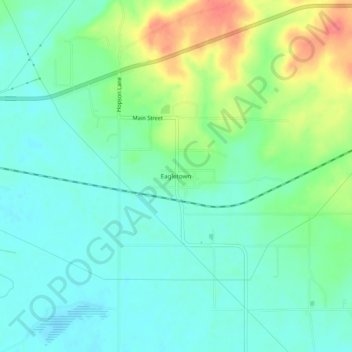
Name: Eagletown topographic map, elevation, terrain.
Location: Eagletown, McCurtain County, Oklahoma, 74734, United States (34.01428 -94.59493 34.05428 -94.55493)
Average elevation: 394 ft
Minimum elevation: 328 ft
Maximum elevation: 545 ft
McCurtain County trails, hiking, mountain biking, running and outdoor activities
Make a donation
Gear up for your next adventure:
As an Amazon Associate, this site earns from qualifying purchases at no extra cost to you.
Other topographic maps
Click on a map to view its topography, its elevation and its terrain.
Broken Bow
United States > Oklahoma > McCurtain County
The city sits at the foothills of the Kiamichi Mountains, a subrange of the Ouachita Mountains. the Kiamichi Mountains sit within Le Flore, Pushmataha, and McCurtain counties near the towns of Poteau and Albion. The Kiamichi peaks line up south of the Kiamichi River and reach 2,500 feet (760 m) in elevation.…
Average elevation: 509 ft
Make a donation
Gear up for your next adventure:
As an Amazon Associate, this site earns from qualifying purchases at no extra cost to you.