
Make a donation
Gear up for your next adventure:
As an Amazon Associate, this site earns from qualifying purchases at no extra cost to you.
Saint-Imier topographic map
Click on the map to display elevation.
Make a donation
Gear up for your next adventure:
As an Amazon Associate, this site earns from qualifying purchases at no extra cost to you.
About this map
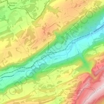
Name: Saint-Imier topographic map, elevation, terrain.
Average elevation: 3,553 ft
Minimum elevation: 2,349 ft
Maximum elevation: 5,131 ft
Make a donation
Gear up for your next adventure:
As an Amazon Associate, this site earns from qualifying purchases at no extra cost to you.
Other topographic maps
Click on a map to view its topography, its elevation and its terrain.
Combe du Bez
Switzerland > Bern > Bernese Jura administrative district > Corgémont
Average elevation: 3,402 ft
Corbez
Switzerland > Bern > Bernese Jura administrative district > Tavannes
Average elevation: 2,671 ft
Chaindon
Switzerland > Bern > Bernese Jura administrative district > Reconvilier
Average elevation: 2,772 ft