
Make a donation
Gear up for your next adventure:
As an Amazon Associate, this site earns from qualifying purchases at no extra cost to you.
Bürgel topographic map
Click on the map to display elevation.
Make a donation
Gear up for your next adventure:
As an Amazon Associate, this site earns from qualifying purchases at no extra cost to you.
About this map
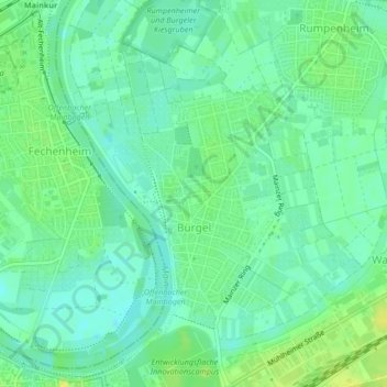
Name: Bürgel topographic map, elevation, terrain.
Location: Bürgel, Offenbach am Main, Hessen, 63075, Deutschland (50.10809 8.76893 50.13198 8.80140)
Average elevation: 335 ft
Minimum elevation: 308 ft
Maximum elevation: 367 ft
Make a donation
Gear up for your next adventure:
As an Amazon Associate, this site earns from qualifying purchases at no extra cost to you.
Other topographic maps
Click on a map to view its topography, its elevation and its terrain.
Offenbach am Main
Deutschland > Hessen > Offenbach am Main
Im Jahr 1812 fand die letzte Hinrichtung in Offenbach statt, der Galgen stand in Höhe Hermannstraße und Schäferstraße.
Average elevation: 456 ft