
Thank you for supporting this site ❤️
Make a donation
Make a donation
Gear up for your next adventure:
As an Amazon Associate, this site earns from qualifying purchases at no extra cost to you.
Salogni topographic map
Click on the map to display elevation.
Thank you for supporting this site ❤️
Make a donation
Make a donation
Gear up for your next adventure:
As an Amazon Associate, this site earns from qualifying purchases at no extra cost to you.
About this map
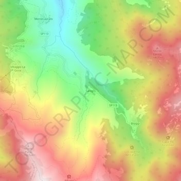
Name: Salogni topographic map, elevation, terrain.
Location: Salogni, Fabbrica Curone, Alessandria, Piemonte, 15054, Italia (44.69827 9.15328 44.73827 9.19328)
Average elevation: 3,770 ft
Minimum elevation: 2,208 ft
Maximum elevation: 5,259 ft
Thank you for supporting this site ❤️
Make a donation
Make a donation
Gear up for your next adventure:
As an Amazon Associate, this site earns from qualifying purchases at no extra cost to you.