
Thank you for supporting this site ❤️
Make a donation
Make a donation
Gear up for your next adventure:
As an Amazon Associate, this site earns from qualifying purchases at no extra cost to you.
Serboli topographic map
Click on the map to display elevation.
Thank you for supporting this site ❤️
Make a donation
Make a donation
Gear up for your next adventure:
As an Amazon Associate, this site earns from qualifying purchases at no extra cost to you.
About this map
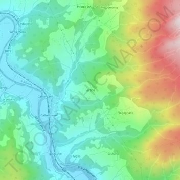
Name: Serboli topographic map, elevation, terrain.
Location: Serboli, Subbiano, Arezzo, Toscana, 52010, Italia (43.59619 11.85687 43.63619 11.89687)
Average elevation: 1,614 ft
Minimum elevation: 876 ft
Maximum elevation: 3,235 ft
Thank you for supporting this site ❤️
Make a donation
Make a donation
Gear up for your next adventure:
As an Amazon Associate, this site earns from qualifying purchases at no extra cost to you.