
Make a donation
Gear up for your next adventure:
As an Amazon Associate, this site earns from qualifying purchases at no extra cost to you.
Chestnut Hill topographic map
Click on the map to display elevation.
Make a donation
Gear up for your next adventure:
As an Amazon Associate, this site earns from qualifying purchases at no extra cost to you.
Chestnut Hill
The village of Chestnut Hill was part of the German Township laid out by Francis Daniel Pastorius and came to include the settlements originally known as Sommerhausen and Crefeld, as well as part of Cresheim. It served as a gateway between Philadelphia and the nearby farmlands. During the American Revolutionary War era (late 18th century), the area was one of many summer vacation spots due to its higher elevation, 400–500 feet (120 to 150 m) above sea level, and cooler temperatures than the historic Center City. Chestnut Hill is still stereotypically known as one of the more affluent sections of Philadelphia. However, there are many residents who fall within lower/middle class incomes.
Make a donation
Gear up for your next adventure:
As an Amazon Associate, this site earns from qualifying purchases at no extra cost to you.
About this map
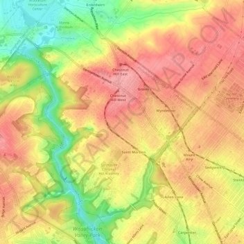
Name: Chestnut Hill topographic map, elevation, terrain.
Average elevation: 318 ft
Minimum elevation: 105 ft
Maximum elevation: 453 ft
Philadelphia County trails, hiking, mountain biking, running and outdoor activities
Make a donation
Gear up for your next adventure:
As an Amazon Associate, this site earns from qualifying purchases at no extra cost to you.
Other topographic maps
Click on a map to view its topography, its elevation and its terrain.
Philadelphia
United States > Pennsylvania > Philadelphia County > Philadelphia
Average elevation: 115 ft
Franklin Delano Roosevelt Park
United States > Pennsylvania > Philadelphia County > Philadelphia
Average elevation: 16 ft
Aviv's Garden
United States > Pennsylvania > Philadelphia County > Philadelphia
Average elevation: 49 ft
Make a donation
Gear up for your next adventure:
As an Amazon Associate, this site earns from qualifying purchases at no extra cost to you.