
Philadelphia topographic map
Click on the map to display elevation.
About this map
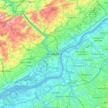
Name: Philadelphia topographic map, elevation, terrain.
Average elevation: 115 ft
Minimum elevation: -59 ft
Maximum elevation: 509 ft
Philadelphia County trails, hiking, mountain biking, running and outdoor activities
Other topographic maps
Click on a map to view its topography, its elevation and its terrain.
Center City
United States > Pennsylvania > Philadelphia County > Philadelphia
Average elevation: 46 ft
South Philadelphia
United States > Pennsylvania > Philadelphia County > Philadelphia
Average elevation: 20 ft
Chestnut Hill
United States > Pennsylvania > Philadelphia County > Philadelphia
The village of Chestnut Hill was part of the German Township laid out by Francis Daniel Pastorius and came to include the settlements originally known as Sommerhausen and Crefeld, as well as part of Cresheim. It served as a gateway between Philadelphia and the nearby farmlands. During the American…
Average elevation: 318 ft
Franklin Delano Roosevelt Park
United States > Pennsylvania > Philadelphia County > Philadelphia
Average elevation: 16 ft
Aviv's Garden
United States > Pennsylvania > Philadelphia County > Philadelphia
Average elevation: 49 ft