
Make a donation
Gear up for your next adventure:
As an Amazon Associate, this site earns from qualifying purchases at no extra cost to you.
Fatu Hiva topographic map
Click on the map to display elevation.
Make a donation
Gear up for your next adventure:
As an Amazon Associate, this site earns from qualifying purchases at no extra cost to you.
Fatu Hiva
The mountain rainforest still harbours some endemic plants, such as Ochrosia fatuhivensis and Melicope fatuhivensis (syn. Pelea fatuhivensis), a tree of the Rutaceae family which may already be extinct. Pterophylla tremuloides is an endemic shrub which grows in low ridge top and cliff shrubland with Metrosideros, Dicranopteris and Lycopodium from 700 to 850 metres elevation. A systematic study of the flora with the support of the Smithsonian Institution in 1988 revealed the number of 175 native, 21 endemic, and 136 anthropochoric plants.
Make a donation
Gear up for your next adventure:
As an Amazon Associate, this site earns from qualifying purchases at no extra cost to you.
About this map
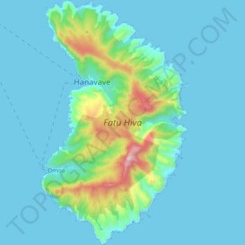
Name: Fatu Hiva topographic map, elevation, terrain.
Average elevation: 423 ft
Minimum elevation: -3 ft
Maximum elevation: 3,343 ft
Make a donation
Gear up for your next adventure:
As an Amazon Associate, this site earns from qualifying purchases at no extra cost to you.