
Thank you for supporting this site ❤️
Make a donation
Make a donation
Gear up for your next adventure:
As an Amazon Associate, this site earns from qualifying purchases at no extra cost to you.
Tremesinos topographic map
Click on the map to display elevation.
Thank you for supporting this site ❤️
Make a donation
Make a donation
Gear up for your next adventure:
As an Amazon Associate, this site earns from qualifying purchases at no extra cost to you.
About this map
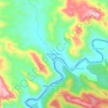
Name: Tremesinos topographic map, elevation, terrain.
Location: Tremesinos, Tiquicheo de Nicolás Romero, Michoacán, México (18.89719 -100.61268 18.93719 -100.57268)
Average elevation: 1,801 ft
Minimum elevation: 1,358 ft
Maximum elevation: 2,575 ft
Thank you for supporting this site ❤️
Make a donation
Make a donation
Gear up for your next adventure:
As an Amazon Associate, this site earns from qualifying purchases at no extra cost to you.