
Make a donation
Gear up for your next adventure:
As an Amazon Associate, this site earns from qualifying purchases at no extra cost to you.
Brauersdorf topographic map
Click on the map to display elevation.
Make a donation
Gear up for your next adventure:
As an Amazon Associate, this site earns from qualifying purchases at no extra cost to you.
Brauersdorf
Brauersdorf liegt im Siegerland, hat eine Fläche von 3,9 km² (inklusive Wald) und liegt im Mittel etwa 325 m über dem Meeresspiegel. Durch den Ort fließt die Obernau, die in der Talsperre mit dem Nauholzbach und anderen kleinen Bächen gestaut wird. Berge in direkter Umgebung sind z. B. der nördlich der Talsperre gelegene Leyberg mit 512 m oder die östlich dieser befindliche Sandhelle mit 522 m Höhe.
Make a donation
Gear up for your next adventure:
As an Amazon Associate, this site earns from qualifying purchases at no extra cost to you.
About this map
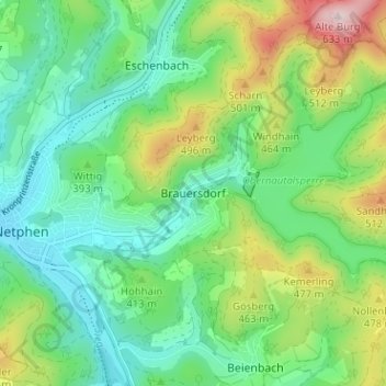
Name: Brauersdorf topographic map, elevation, terrain.
Average elevation: 1,276 ft
Minimum elevation: 928 ft
Maximum elevation: 2,070 ft
Make a donation
Gear up for your next adventure:
As an Amazon Associate, this site earns from qualifying purchases at no extra cost to you.
Other topographic maps
Click on a map to view its topography, its elevation and its terrain.
Grissenbach
Deutschland > Nordrhein-Westfalen > Kreis Siegen-Wittgenstein > Netphen
Average elevation: 1,342 ft
Unglinghausen
Deutschland > Nordrhein-Westfalen > Kreis Siegen-Wittgenstein > Netphen
Average elevation: 1,217 ft
Oelgershausen
Deutschland > Nordrhein-Westfalen > Kreis Siegen-Wittgenstein > Netphen
Average elevation: 1,148 ft
Salchendorf
Deutschland > Nordrhein-Westfalen > Kreis Siegen-Wittgenstein > Netphen
Die Bebauung des Orts befindet sich auf einer Höhe zwischen 330 und 390 m ü. NHN. Die Gemarkung Salchendorf hat eine Fläche von 9,2 km². Berge und Erhebungen um Salchendorf sind unter anderem Heinenberg 530,7 m, Rübenhain, Auf der Noll mit 474,1 m und der Haferhain mit 503,5 m Höhe. Durch den Ort fließt…
Average elevation: 1,322 ft
Make a donation
Gear up for your next adventure:
As an Amazon Associate, this site earns from qualifying purchases at no extra cost to you.
Werthenbach
Deutschland > Nordrhein-Westfalen > Kreis Siegen-Wittgenstein > Netphen
Average elevation: 1,604 ft
Helgersdorf
Deutschland > Nordrhein-Westfalen > Kreis Siegen-Wittgenstein > Netphen
Average elevation: 1,358 ft
Nenkersdorf
Deutschland > Nordrhein-Westfalen > Kreis Siegen-Wittgenstein > Netphen > Nenkersdorf
Average elevation: 1,594 ft
Sohlbach
Deutschland > Nordrhein-Westfalen > Kreis Siegen-Wittgenstein > Netphen > Sohlbach
Average elevation: 1,611 ft
Make a donation
Gear up for your next adventure:
As an Amazon Associate, this site earns from qualifying purchases at no extra cost to you.