Geolocate

Vértes topographic map

Click on the map to display elevation.

Vértes

The area of the Vértes occupies 314 km2 (121 sq mi). It is about 30 km long and 10–15 km wide. The average altitude is above sea level is 350 meters; its highest points are 487 m (Nagy-Csákány), 480 m (Körtvélyes) and 479 m (Csóka-hegy). Geologically the Vértes constitute a fairly uniform structure. On the surface of the entire mountain there are no older rocks than those of the mid-Triassic. The main rock is dolomite—CaMg(CO3)2—from the upper Triassic. All the layers are ancient marine deposits.

Wikipedia (CC-BY-SA 3.0)

About this map

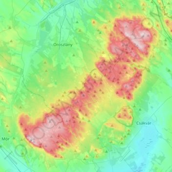
Name: Vértes topographic map, elevation, terrain.

Location: Vértes, Komárom-Esztergom, Central Transdanubia, Transdanubia, Hungary (47.33039 18.21991 47.54475 18.50522)

Average elevation: 804 ft

Minimum elevation: 420 ft

Maximum elevation: 1,611 ft

Other topographic maps

Click on a map to view its topography, its elevation and its terrain.

Esztergom

Hungary > Komárom-Esztergom

Average elevation: 617 ft

Várgesztes

Hungary > Komárom-Esztergom

Average elevation: 1,106 ft

Kesztölc

Hungary > Komárom-Esztergom

Average elevation: 843 ft

Piliscsév

Hungary > Komárom-Esztergom

Average elevation: 919 ft

Tardos

Hungary > Komárom-Esztergom

Average elevation: 1,181 ft

Bokod

Hungary > Komárom-Esztergom

Average elevation: 689 ft

Dorog

Hungary > Komárom-Esztergom

Average elevation: 591 ft

Ács

Hungary > Komárom-Esztergom

Average elevation: 407 ft

Tatabánya

Hungary > Komárom-Esztergom

Average elevation: 751 ft

Tata

Hungary > Komárom-Esztergom

Average elevation: 607 ft

Tata

Hungary > Komárom-Esztergom

Average elevation: 607 ft

Dad

Hungary > Komárom-Esztergom

Average elevation: 659 ft

Neszmély

Hungary > Komárom-Esztergom

Average elevation: 650 ft

Vértesszőlős

Hungary > Komárom-Esztergom

Average elevation: 748 ft

2948

Hungary > Komárom-Esztergom > Kisigmánd

Average elevation: 443 ft

Naszály

Hungary > Komárom-Esztergom

Average elevation: 420 ft

Almásfüzitő

Hungary > Komárom-Esztergom

Average elevation: 361 ft

Oroszlány

Hungary > Komárom-Esztergom

Average elevation: 804 ft

Bokod

Hungary > Komárom-Esztergom

Average elevation: 689 ft

Tatabánya

Hungary > Komárom-Esztergom

Average elevation: 751 ft

Nagysáp

Hungary > Komárom-Esztergom > Nagysáp > Nagysáp

Average elevation: 646 ft

Tatabánya

Hungary > Komárom-Esztergom > Tatabánya

Average elevation: 715 ft

Annavölgy

Hungary > Komárom-Esztergom > Annavölgy

Average elevation: 597 ft

Szárliget

Hungary > Komárom-Esztergom

Average elevation: 932 ft

Kecskéd

Hungary > Komárom-Esztergom

Average elevation: 577 ft

Gear up for your next adventure:

🎁Geography Themed Gifts - Unique gift ideas for map lovers and geography enthusiasts
🪶Multi‑Purpose Knife - Useful blade for camp and trail
📌Outdoor GPS Map App - Apps and devices for digital topographic navigation
🎒Hydration Pack - Hands‑free water reservoir for long hikes
🗺️Topographic Maps - Detailed topo maps for hiking, exploring and outdoor navigation

As an Amazon Associate, this site earns from qualifying purchases at no extra cost to you.