Geolocate

Bousson topographic map

Click on the map to display elevation.

About this map

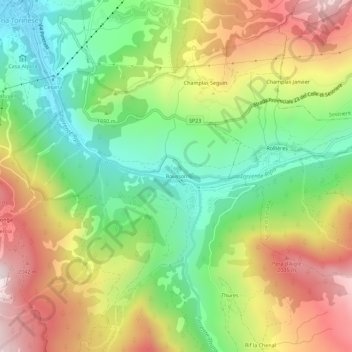
Name: Bousson topographic map, elevation, terrain.

Location: Bousson, Cesana Torinese, Torino, Piemonte, 10054, Italia (44.91468 6.79711 44.95468 6.83711)

Average elevation: 5,571 ft

Minimum elevation: 4,400 ft

Maximum elevation: 7,073 ft

Other topographic maps

Click on a map to view its topography, its elevation and its terrain.

Valle Thuras

Italia > Piemonte > Torino > Cesana Torinese

Average elevation: 7,920 ft

Gear up for your next adventure:

🌎3D Topographic Globes - Raised relief globes for a tactile understanding of geography
🪶Thermal Camp Blanket - Extra warmth for cold nights
🧦Merino Wool Socks - Moisture-wicking, blister-preventing socks for long treks
👖Convertible Hiking Pants - Versatile zip-off pants for changing altitudes and temperatures
🔥Camping Stove - Portable stove for camping and backcountry cooking

As an Amazon Associate, this site earns from qualifying purchases at no extra cost to you.