
Make a donation
Gear up for your next adventure:
As an Amazon Associate, this site earns from qualifying purchases at no extra cost to you.
Same topographic map
Click on the map to display elevation.
Make a donation
Gear up for your next adventure:
As an Amazon Associate, this site earns from qualifying purchases at no extra cost to you.
Same
The city is located in the interior of the island, 49 kilometres (30 mi) south of the provincial capital of Dili, at an altitude of 384 metres (1,260 ft), south of the mountain Cabalaki (Foho Kabulaki). The centre is located in the Suco Letefoho in which are situated the districts Ria-Lau (Rialau) Manico 1, 2 Manico, Cotalala (Kotalala), Rai-Ubo (Raiubu) and Akadiruhun. The suburbs Manikun, Lia-Nai (Lianai), Maibuti (Maihuti), Raimera (Raimerak), Searema (Scarema, Serema), Uma-Liurai (Umaliurai, Umahurai), Nunu-Fu (Nunufu), Babulo und Lapuro (Laiuru) are in the Suco Babulo. An overland road leads from Same to Maubisse in the north and Betano in the south. One branch leads to Alas and Welaluhu in the East. Both Sucos are classified as "urban". Same has 11,258 inhabitants (2010).
Make a donation
Gear up for your next adventure:
As an Amazon Associate, this site earns from qualifying purchases at no extra cost to you.
About this map
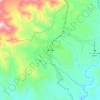
Name: Same topographic map, elevation, terrain.
Location: Same, Manufahi, East Timor (-9.04362 125.60777 -8.96362 125.68777)
Average elevation: 1,742 ft
Minimum elevation: 584 ft
Maximum elevation: 4,560 ft
Make a donation
Gear up for your next adventure:
As an Amazon Associate, this site earns from qualifying purchases at no extra cost to you.