
Managua topographic map
Interactive map
Click on the map to display elevation.
About this map
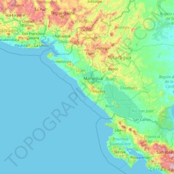
Name: Managua topographic map, elevation, terrain.
Location: Managua, Nicaragua (9.40028 -89.05345 14.60028 -83.85345)
Average elevation: 778 ft
Minimum elevation: -3 ft
Maximum elevation: 10,906 ft
Other topographic maps
Click on a map to view its topography, its elevation and its terrain.
Tipitapa (Municipio)
Tipitapa (Municipio), Managua, 15100, Nicaragua
Average elevation: 509 ft
Francisco Morazán
Francisco Morazán, Distrito II, Managua, 12012, Nicaragua
Average elevation: 213 ft