Geolocate

Mathews topographic map

Click on the map to display elevation.

About this map

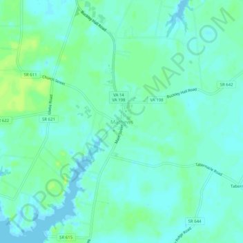
Name: Mathews topographic map, elevation, terrain.

Location: Mathews, Mathews County, Virginia, 23109, United States (37.41374 -76.34107 37.45374 -76.30107)

Average elevation: 16 ft

Minimum elevation: -10 ft

Maximum elevation: 39 ft

Mathews County trails, hiking, mountain biking, running and outdoor activities

Other topographic maps

Click on a map to view its topography, its elevation and its terrain.

Gwynn's Island

United States > Virginia > Mathews County > Gwynn

Average elevation: 7 ft

Gear up for your next adventure:

Solar GPS Watches - Advanced multisport watches with built-in topographic maps
😴Insulated Sleeping Pads - Compact and warm pads for high-elevation camping
🥩Freeze-Dried Meals - Nutritious and lightweight food for remote expeditions
🏫Relief Map Kits - Hands-on tools for teaching landforms and elevation
🧭GPS Watch Accessories - Bands and chargers for GPS watches

As an Amazon Associate, this site earns from qualifying purchases at no extra cost to you.