Geolocate

Collem topographic map

Click on the map to display elevation.

About this map

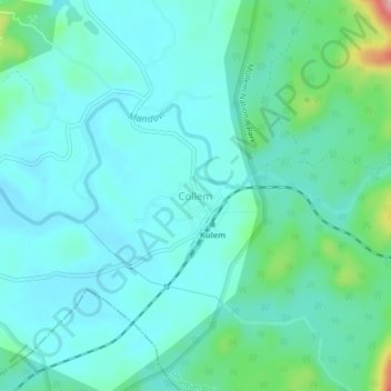
Name: Collem topographic map, elevation, terrain.

Location: Collem, Dharbandora, South Goa District, Goa, India (15.31714 74.22275 15.35714 74.26275)

Average elevation: 295 ft

Minimum elevation: 190 ft

Maximum elevation: 768 ft

Other topographic maps

Click on a map to view its topography, its elevation and its terrain.

Codli

India > Goa > Dharbandora

Average elevation: 217 ft

Gear up for your next adventure:

📶Vehicle Signal Boosters - Improve reception in rural areas while driving to trailheads
🖼️Topo Map Wall Art - Decorative topographic prints of famous peaks and regions
📱Heavy-Duty Phone Cases - Drop-proof and waterproof protection for outdoor navigation
🍳Camping Cook Set - Complete cookware for outdoor meals
🪶Survival Guide Book - Expert advice for emergency preparedness

As an Amazon Associate, this site earns from qualifying purchases at no extra cost to you.