
Make a donation
Gear up for your next adventure:
As an Amazon Associate, this site earns from qualifying purchases at no extra cost to you.
Handewitt topographic map
Click on the map to display elevation.
Make a donation
Gear up for your next adventure:
As an Amazon Associate, this site earns from qualifying purchases at no extra cost to you.
Handewitt
Das Gemeindegebiet erstreckt sich im Norden des Naturraums Schleswiger Vorgeest unmittelbar an der Staatsgrenze zu Dänemark. Höchstgelegene Stelle im Gemeindegebiet ist der Trommelberg (dän. Trimmelbjerg, abgeleitet von dän. trimle für purzeln, rollen) im Handewitter Forst mit einer Höhe von 62,1 m ü. NHN bei Lage54.7551859.36303.
Make a donation
Gear up for your next adventure:
As an Amazon Associate, this site earns from qualifying purchases at no extra cost to you.
About this map
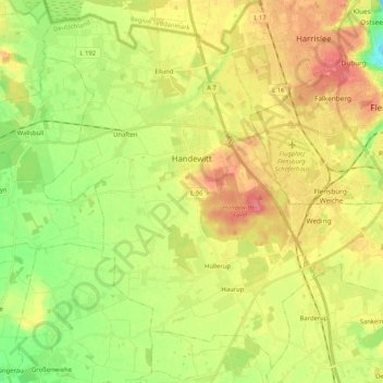
Name: Handewitt topographic map, elevation, terrain.
Average elevation: 108 ft
Minimum elevation: 0 ft
Maximum elevation: 217 ft
Make a donation
Gear up for your next adventure:
As an Amazon Associate, this site earns from qualifying purchases at no extra cost to you.
Other topographic maps
Click on a map to view its topography, its elevation and its terrain.
Glücksburg (Ostsee)
Deutschland > Schleswig-Holstein > Kreis Schleswig-Flensburg > Glücksburg (Ostsee)
Average elevation: 56 ft
Steinberghaff
Deutschland > Schleswig-Holstein > Kreis Schleswig-Flensburg > Steinbergholz
Average elevation: 13 ft
Make a donation
Gear up for your next adventure:
As an Amazon Associate, this site earns from qualifying purchases at no extra cost to you.
Terkelstoft
Deutschland > Schleswig-Holstein > Kreis Schleswig-Flensburg > Streichmühle
Average elevation: 95 ft
Make a donation
Gear up for your next adventure:
As an Amazon Associate, this site earns from qualifying purchases at no extra cost to you.
Make a donation
Gear up for your next adventure:
As an Amazon Associate, this site earns from qualifying purchases at no extra cost to you.
Lüttfeld
Deutschland > Schleswig-Holstein > Kreis Schleswig-Flensburg > Kappeln
Average elevation: 39 ft
Make a donation
Gear up for your next adventure:
As an Amazon Associate, this site earns from qualifying purchases at no extra cost to you.
Schausende
Deutschland > Schleswig-Holstein > Kreis Schleswig-Flensburg > Glücksburg (Ostsee)
Average elevation: 10 ft
Sörupmühle
Deutschland > Schleswig-Holstein > Kreis Schleswig-Flensburg > Flatzby
Average elevation: 144 ft
Make a donation
Gear up for your next adventure:
As an Amazon Associate, this site earns from qualifying purchases at no extra cost to you.
Brarupholz
Deutschland > Schleswig-Holstein > Kreis Schleswig-Flensburg > Scheggerott
Average elevation: 138 ft
Ulsnisland
Deutschland > Schleswig-Holstein > Kreis Schleswig-Flensburg > Ulsnis
Average elevation: 43 ft
Alt Hasselberg
Deutschland > Schleswig-Holstein > Kreis Schleswig-Flensburg > Hasselberg
Average elevation: 10 ft
Tolkschuby
Deutschland > Schleswig-Holstein > Kreis Schleswig-Flensburg > Tolk
Average elevation: 75 ft
Make a donation
Gear up for your next adventure:
As an Amazon Associate, this site earns from qualifying purchases at no extra cost to you.
Rabenkirchen
Deutschland > Schleswig-Holstein > Kreis Schleswig-Flensburg > Rabenkirchen-Faulück
Average elevation: 102 ft
Ulegraff
Deutschland > Schleswig-Holstein > Kreis Schleswig-Flensburg > Brunsholm
Average elevation: 141 ft
Make a donation
Gear up for your next adventure:
As an Amazon Associate, this site earns from qualifying purchases at no extra cost to you.
Gammelbyholz
Deutschland > Schleswig-Holstein > Kreis Schleswig-Flensburg > Sörup
Average elevation: 125 ft
Altholzkrug
Deutschland > Schleswig-Holstein > Kreis Schleswig-Flensburg > Handewitt
Average elevation: 131 ft
Make a donation
Gear up for your next adventure:
As an Amazon Associate, this site earns from qualifying purchases at no extra cost to you.
Lüttfeld
Deutschland > Schleswig-Holstein > Kreis Schleswig-Flensburg > Kappeln
Average elevation: 39 ft
Make a donation
Gear up for your next adventure:
As an Amazon Associate, this site earns from qualifying purchases at no extra cost to you.
Unewattfeld
Deutschland > Schleswig-Holstein > Kreis Schleswig-Flensburg > Unewatt
Average elevation: 89 ft
Steinberggaard
Deutschland > Schleswig-Holstein > Kreis Schleswig-Flensburg > Steinberg
Average elevation: 49 ft
Rückeberg
Deutschland > Schleswig-Holstein > Kreis Schleswig-Flensburg > Kappeln
Average elevation: 39 ft
Make a donation
Gear up for your next adventure:
As an Amazon Associate, this site earns from qualifying purchases at no extra cost to you.
Uelsbyholz
Deutschland > Schleswig-Holstein > Kreis Schleswig-Flensburg > Uelsby
Average elevation: 144 ft
Schnarup
Deutschland > Schleswig-Holstein > Kreis Schleswig-Flensburg > Schnarup-Thumby
Average elevation: 102 ft
Make a donation
Gear up for your next adventure:
As an Amazon Associate, this site earns from qualifying purchases at no extra cost to you.