Geolocate

Cameri topographic map

Click on the map to display elevation.

About this map

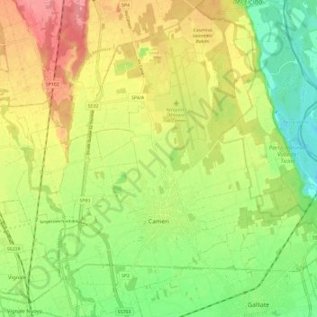
Name: Cameri topographic map, elevation, terrain.

Location: Cameri, Novara, Piemonte, 28062, Italia (45.47500 8.60846 45.55617 8.71940)

Average elevation: 551 ft

Minimum elevation: 417 ft

Maximum elevation: 699 ft

Other topographic maps

Click on a map to view its topography, its elevation and its terrain.

Sovazza

Italia > Piemonte > Novara

Average elevation: 2,238 ft

Gaggiolo

Italia > Piemonte > Novara

Average elevation: 692 ft

Gattico

Italia > Piemonte > Novara

Average elevation: 1,109 ft

Fosseno

Italia > Piemonte > Novara

Average elevation: 1,798 ft

Coiromonte

Italia > Piemonte > Novara

Average elevation: 2,425 ft

Tabarino

Italia > Piemonte > Novara

Average elevation: 1,821 ft

Gear up for your next adventure:

🏔️Mountain Trail Maps - High‑detail maps for popular peaks
🧤Tactile Hiking Gloves - Keep hands warm while operating GPS and smartphone screens
📻Weather Alert Radios - Stay informed of storm risks while off-the-grid
🧣Hiking Neck Gaiter - Multi‑use neck protection for outdoor weather
🪑Ultralight Camp Chairs - Portable seating for resting after a long day of mapping

As an Amazon Associate, this site earns from qualifying purchases at no extra cost to you.