
Make a donation
Gear up for your next adventure:
As an Amazon Associate, this site earns from qualifying purchases at no extra cost to you.
Crognaleto topographic map
Click on the map to display elevation.
Make a donation
Gear up for your next adventure:
As an Amazon Associate, this site earns from qualifying purchases at no extra cost to you.
Crognaleto
Crognaleto is a comune and city of slightly less than 2,000 people in the Province of Teramo, central Italy. Crognaleto sits at an elevation of 1,105 metres (3,625 ft) and has its communal administrative offices in the frazione (outlying area) of Nerito. The commune of Crognaleto sits on the slopes of the Monti della Laga mountain range and extends across both the northern and the southern slopes of the Vomano Valley. It lies within the Gran Sasso e Monti della Laga National Park.
Make a donation
Gear up for your next adventure:
As an Amazon Associate, this site earns from qualifying purchases at no extra cost to you.
About this map
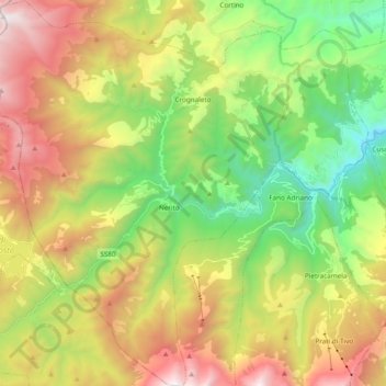
Name: Crognaleto topographic map, elevation, terrain.
Location: Crognaleto, Teramo, Abruzzo, 64043, Italy (42.48322 13.38908 42.62395 13.57659)
Average elevation: 3,980 ft
Minimum elevation: 1,076 ft
Maximum elevation: 8,018 ft
Make a donation
Gear up for your next adventure:
As an Amazon Associate, this site earns from qualifying purchases at no extra cost to you.
Other topographic maps
Click on a map to view its topography, its elevation and its terrain.
Make a donation
Gear up for your next adventure:
As an Amazon Associate, this site earns from qualifying purchases at no extra cost to you.
Make a donation
Gear up for your next adventure:
As an Amazon Associate, this site earns from qualifying purchases at no extra cost to you.