Geolocate

Mount Field topographic map

Click on the map to display elevation.

About this map

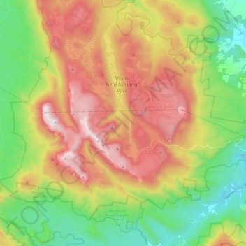
Name: Mount Field topographic map, elevation, terrain.

Location: Mount Field, Derwent Valley, Tasmania, 7140, Australia (-42.73268 146.48694 -42.59515 146.72339)

Average elevation: 2,362 ft

Minimum elevation: 594 ft

Maximum elevation: 4,659 ft

Other topographic maps

Click on a map to view its topography, its elevation and its terrain.

Cathedral Mountain

Australia > Tasmania

Average elevation: 3,255 ft

Waterworks Reserve

Australia > Tasmania > Hobart

Average elevation: 787 ft

Rowlands Hill

Australia > Tasmania

Average elevation: 1,273 ft

Cradle Mountain

Australia > Tasmania > Cradle Mountain

Average elevation: 3,753 ft

The Nut

Australia > Tasmania > Stanley

Average elevation: 26 ft

Bream Creek

Australia > Tasmania > Bream Creek

Average elevation: 115 ft

Buxton Point

Australia > Tasmania > Little Swanport

Average elevation: 10 ft

Mount Patrick

Australia > Tasmania

Average elevation: 2,831 ft

Mount Ossa

Australia > Tasmania

Average elevation: 3,996 ft

West Gawler River

Australia > Tasmania > Sprent > Gawler

Average elevation: 659 ft

Mount Tyndall

Australia > Tasmania

Average elevation: 2,986 ft

Gear up for your next adventure:

🧭Compass with Lanyard - Easy‑carry compass for navigation
🔦Powerful Headlamps - Ultra-bright hands-free lighting for night navigation
📖Nature Tracking Books - Learn to track wildlife and terrain
🎒Trekking Poles - Sturdy poles for balance and stability on rough terrain
👟Men's Trail Runners - Lightweight footwear for fast-paced exploration and light hiking

As an Amazon Associate, this site earns from qualifying purchases at no extra cost to you.