
Make a donation
Gear up for your next adventure:
As an Amazon Associate, this site earns from qualifying purchases at no extra cost to you.
Amarete topographic map
Click on the map to display elevation.
Make a donation
Gear up for your next adventure:
As an Amazon Associate, this site earns from qualifying purchases at no extra cost to you.
Amarete
Amarete es una comunidad en Bolivia, perteneciente al municipio de Charazani de la provincia de Bautista Saavedra, en el departamento de La Paz. Limita al sur y al este con otras comunidades de origen quechua y aymara, al oeste con la Provincia de Muñecas y al noroeste con Perú. La comunidad se encuentra a una altitud de 2800 a 3800 m s. n. m. y es una de las comunidades más grandes del municipio.
Make a donation
Gear up for your next adventure:
As an Amazon Associate, this site earns from qualifying purchases at no extra cost to you.
About this map
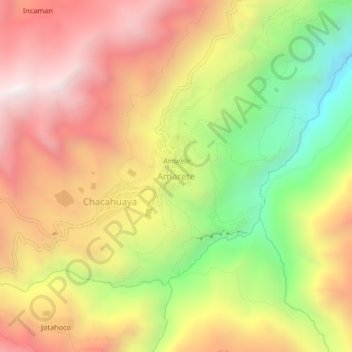
Name: Amarete topographic map, elevation, terrain.
Average elevation: 12,687 ft
Minimum elevation: 10,325 ft
Maximum elevation: 14,695 ft
Make a donation
Gear up for your next adventure:
As an Amazon Associate, this site earns from qualifying purchases at no extra cost to you.
Other topographic maps
Click on a map to view its topography, its elevation and its terrain.
Soto Pata
Bolivia > La Paz > Provincia Bautista Saavedra > Municipio Charazani
Average elevation: 3,346 ft
Pauje Yuyo
Bolivia > La Paz > Provincia Bautista Saavedra > Municipio Charazani
Average elevation: 3,986 ft
Santa Rosa de Caata
Bolivia > La Paz > Provincia Bautista Saavedra > Municipio Charazani
Average elevation: 11,985 ft