Geolocate

Alach topographic map

Click on the map to display elevation.

About this map

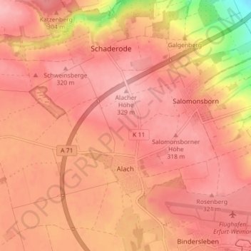
Name: Alach topographic map, elevation, terrain.

Location: Alach, Erfurt, Thuringia, Germany (50.97438 10.88855 51.01559 10.95879)

Average elevation: 978 ft

Minimum elevation: 663 ft

Maximum elevation: 1,083 ft

Other topographic maps

Click on a map to view its topography, its elevation and its terrain.

Linderbach

Germany > Thuringia > Erfurt

Average elevation: 738 ft

Marbach

Germany > Thuringia > Erfurt

Average elevation: 738 ft

Wallichen

Germany > Thuringia > Erfurt

Average elevation: 650 ft

Gear up for your next adventure:

🧷Carabiner Set - Durable clips for gear attachment
Backpacking Tents - Weight-optimized shelters for multi-day topographic surveys
🧦Merino Wool Socks - Moisture-wicking, blister-preventing socks for long treks
🔥Plasma Lighters - Windproof lighters that work in any weather condition
🌡️Portable Weather Meter - Track weather conditions on the trail

As an Amazon Associate, this site earns from qualifying purchases at no extra cost to you.