
Thank you for supporting this site ❤️
Make a donation
Make a donation
Gear up for your next adventure:
As an Amazon Associate, this site earns from qualifying purchases at no extra cost to you.
Bodimettu topographic map
Click on the map to display elevation.
Thank you for supporting this site ❤️
Make a donation
Make a donation
Gear up for your next adventure:
As an Amazon Associate, this site earns from qualifying purchases at no extra cost to you.
About this map
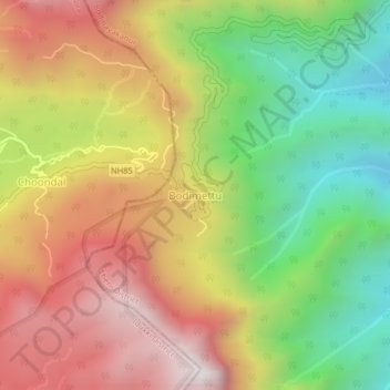
Name: Bodimettu topographic map, elevation, terrain.
Location: Bodimettu, Bodinayakanur, Theni District, Tamil Nadu, India (9.99989 77.24455 10.03989 77.28455)
Average elevation: 4,091 ft
Minimum elevation: 1,873 ft
Maximum elevation: 6,368 ft
Thank you for supporting this site ❤️
Make a donation
Make a donation
Gear up for your next adventure:
As an Amazon Associate, this site earns from qualifying purchases at no extra cost to you.