Geolocate

Ellerslie topographic map

Click on the map to display elevation.

About this map

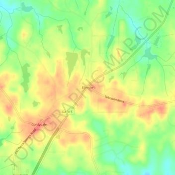
Name: Ellerslie topographic map, elevation, terrain.

Location: Ellerslie, Harris County, Georgia, 31807, United States (32.61135 -84.82175 32.65135 -84.78175)

Average elevation: 682 ft

Minimum elevation: 591 ft

Maximum elevation: 758 ft

Harris County trails, hiking, mountain biking, running and outdoor activities

Other topographic maps

Click on a map to view its topography, its elevation and its terrain.

Hamilton

United States > Georgia > Harris County

Average elevation: 810 ft

Shiloh

United States > Georgia > Harris County

Average elevation: 866 ft

Waverly Hall

United States > Georgia > Harris County

Average elevation: 712 ft

Whitesville

United States > Georgia > Harris County

Average elevation: 682 ft

Pine Mountain

United States > Georgia > Harris County

Average elevation: 899 ft

Gear up for your next adventure:

🪶Wildlife Field Guides - Learn animal tracking and species ID
📖Nature Tracking Books - Learn to track wildlife and terrain
🚗GPS Dash Cams - Record your scenic drives through mountain passes and canyons
Solar GPS Watches - Advanced multisport watches with built-in topographic maps
🛏️Cold Weather Sleeping Bag - Warm sleeping bag for cold conditions

As an Amazon Associate, this site earns from qualifying purchases at no extra cost to you.