
Make a donation
Gear up for your next adventure:
As an Amazon Associate, this site earns from qualifying purchases at no extra cost to you.
Dennison topographic map
Click on the map to display elevation.
Make a donation
Gear up for your next adventure:
As an Amazon Associate, this site earns from qualifying purchases at no extra cost to you.
About this map
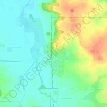
Name: Dennison topographic map, elevation, terrain.
Location: Dennison, Goodhue County, Minnesota, United States (44.39977 -93.04210 44.41788 -93.01984)
Average elevation: 994 ft
Minimum elevation: 935 ft
Maximum elevation: 1,096 ft
Goodhue County trails, hiking, mountain biking, running and outdoor activities
Make a donation
Gear up for your next adventure:
As an Amazon Associate, this site earns from qualifying purchases at no extra cost to you.
Other topographic maps
Click on a map to view its topography, its elevation and its terrain.
Grand View Mobile Park
United States > Minnesota > Goodhue County > Red Wing
Average elevation: 817 ft
Cannon Falls
United States > Minnesota > Goodhue County > Cannon Falls > Cannon Falls
Average elevation: 879 ft