
Make a donation
Gear up for your next adventure:
As an Amazon Associate, this site earns from qualifying purchases at no extra cost to you.
Timmendorfer Strand topographic map
Click on the map to display elevation.
Make a donation
Gear up for your next adventure:
As an Amazon Associate, this site earns from qualifying purchases at no extra cost to you.
Timmendorfer Strand
Die Gemeinde Timmendorfer Strand liegt 15 Kilometer nördlich von Lübeck direkt an der Ostseeküste. Naturräumlich zählt das Gemeindegebiet zum südöstlichen Teilbereich der naturräumlichen Haupteinheit Ostholsteinisches Hügel- und Seenland. Nachbargemeinden sind Scharbeutz im Norden, Ratekau im Süden und Westen sowie Lübeck – mit dem Stadtteil Travemünde – im Osten. Der Strand an der Lübecker Bucht ist 6,5 Kilometer lang. Das Landschaftsbild um Timmendorfer Strand wird durch die Grundmoränen der letzten Eiszeit geprägt. Die Ablagerungen der Weichsel-Eiszeit schufen ein abwechslungsreiches, leicht hügeliges Relief mit vielen Seen. Der reizvolle Hemmelsdorfer See entstand aus einer von der Ostsee abgeschnittenen Förde. An seinem Grund befindet sich mit 39,6 Metern unter Meereshöhe der tiefste naturgeschaffene Punkt Deutschlands. Ein weiteres typisches Merkmal für das Landschaftsbild um Timmendorfer Strand sind die unter Naturschutz stehenden Knicks.
Make a donation
Gear up for your next adventure:
As an Amazon Associate, this site earns from qualifying purchases at no extra cost to you.
About this map
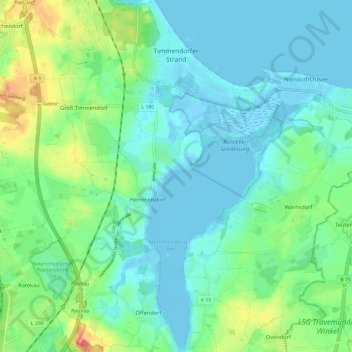
Name: Timmendorfer Strand topographic map, elevation, terrain.
Average elevation: 49 ft
Minimum elevation: -13 ft
Maximum elevation: 190 ft
Make a donation
Gear up for your next adventure:
As an Amazon Associate, this site earns from qualifying purchases at no extra cost to you.
Other topographic maps
Click on a map to view its topography, its elevation and its terrain.
Burg auf Fehmarn
Deutschland > Schleswig-Holstein > Kreis Ostholstein > Fehmarn
Average elevation: 20 ft
Pelzerhaken
Deutschland > Schleswig-Holstein > Kreis Ostholstein > Neustadt in Holstein
Average elevation: 26 ft
Make a donation
Gear up for your next adventure:
As an Amazon Associate, this site earns from qualifying purchases at no extra cost to you.
Putlos
Deutschland > Schleswig-Holstein > Kreis Ostholstein > Oldenburg in Holstein
Average elevation: 30 ft
Taschensee
Deutschland > Schleswig-Holstein > Kreis Ostholstein > Scharbeutz > Gronenberg
Average elevation: 85 ft
Make a donation
Gear up for your next adventure:
As an Amazon Associate, this site earns from qualifying purchases at no extra cost to you.
Make a donation
Gear up for your next adventure:
As an Amazon Associate, this site earns from qualifying purchases at no extra cost to you.
Anschottredder
Deutschland > Schleswig-Holstein > Kreis Ostholstein > Bujendorf
Average elevation: 167 ft
Pönitz am See
Deutschland > Schleswig-Holstein > Kreis Ostholstein > Scharbeutz
Average elevation: 82 ft
Make a donation
Gear up for your next adventure:
As an Amazon Associate, this site earns from qualifying purchases at no extra cost to you.
Holzbergturm
Deutschland > Schleswig-Holstein > Kreis Ostholstein > Malente > Neversfelde
Der erste Holzbergturm wurde im Jahr 2000 von Mitgliedern des Verschönerungsvereins Neversfelde e.V. entworfen. Im Juni 2004 begannen die Bauarbeiten, die im Frühjahr 2005 abgeschlossen waren. Die Eröffnung des 28,5 Meter hohen, aus Lärchenholz errichteten Turms erfolgte im Juli 2005. Die Baukosten…
Average elevation: 131 ft
Make a donation
Gear up for your next adventure:
As an Amazon Associate, this site earns from qualifying purchases at no extra cost to you.
Make a donation
Gear up for your next adventure:
As an Amazon Associate, this site earns from qualifying purchases at no extra cost to you.
Langenhagen
Deutschland > Schleswig-Holstein > Kreis Ostholstein > Schönwalde am Bungsberg
Average elevation: 361 ft
Make a donation
Gear up for your next adventure:
As an Amazon Associate, this site earns from qualifying purchases at no extra cost to you.
Krummsee
Deutschland > Schleswig-Holstein > Kreis Ostholstein > Malente > Krummsee > Bruhnskoppel
Average elevation: 157 ft
Neustädter Bucht
Deutschland > Schleswig-Holstein > Kreis Ostholstein > Neustadt in Holstein
Average elevation: 16 ft
Hohwachter Bucht
Deutschland > Schleswig-Holstein > Kreis Ostholstein > Gremersdorf
Average elevation: 16 ft
Make a donation
Gear up for your next adventure:
As an Amazon Associate, this site earns from qualifying purchases at no extra cost to you.
Grammdorf
Deutschland > Schleswig-Holstein > Kreis Ostholstein
Die Christuskirche wurde auf der Kammhöhe eines eiszeitlichen Moränenzuges errichtet. Der Bau wurde 1896 an der Stelle einer Kirche des 13. Jahrhunderts errichtet. Er weist an der südöstlichen Seite ein Feldsteinmauerwerk auf. Beim Bau verwendete der Hamburger Architekt Hugo Groothoff behauene Feldsteine…
Average elevation: 105 ft
Make a donation
Gear up for your next adventure:
As an Amazon Associate, this site earns from qualifying purchases at no extra cost to you.